JAMSTEC VENTURE Forecast Ocean + Plus


Research&Development
On the basis of the world's most advanced ocean forecast in physical oceanography, we are operating research and development with associated businesses and relivant ministries.
Contact info
About our ocean model
In order to offer various solutions, we have several ocean models.
- JCOPE2 and FIO are regional models for North-west pacific ocean and Indian ocean each. These forecast data is surface height and current, temperature, salinity from 0 to 6500m depth with the horizontal resolution 1/12 degree.
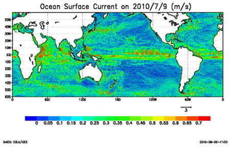
- FGO is a high-resolution global model with the horizontal resolution 1/10 degree. This daily forecast data is the world's first commercial product.
- JCOPE-t is an ultra-high-resolution regional model coupled with a tidal model with the horizontal resolution 1/36 degree. The forecast data including tidal variations are provided everyday.
Details in JCOPE2
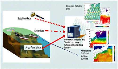
The JCOPE was started in October 1997 under the initiative of the Climate Variations Research Program of Frontier Research Center for Global Change (FRCGC) , which is supported by Japan Agency for Marine-Earth Science and Technology (JAMSTEC) . The JCOPE system is near operational and gives experimental current predictions using almost all available data obtained from satellites, ARGO floats and ships. The routine prediction of sea state ("ocean weather forecast", Yamagata, 2002), in addition to the monitoring of in-situ data, will significantly contribute to improve even the atmosphere-ocean coupled models for prediction of longer-term climate variations. The JCOPE is based on one of world community models, Princeton Ocean Model (POM/POMgcs) . A high-resolution,regional model with spatial grid of 1/12 degree and 46 sigma levels is embedded to a low-resolution basin-wide model with spatial grid resolution of about 1/4 degree and with 21 sigma levels. The former model domain covers the Northwest Pacific (117E-180E, 12N-62N) and its lateral boundary condition is specified using the one-way nesting method (Guo et al., 2003) from the latter model. The model could simulate three typical paths of the Kuroshio south of Japan as well as the meso-scale eddies (Miyazawa et al., 2002). The Kuroshio meanders on three different paths: large mender path, nonlarge meander path and near-shore path. The JCOPE is also very successful in predicting the Kuroshio and its meandering, the coastal currents near the Japan coast and currents in Kuroshio extension region. The following figure shows a comparison of Kuroshio flow structure along 138E between model results. (averaged for 2004/08/31-2004/09/01) and ADCP data (averaged for the period2004/08/31-2004/09/04).
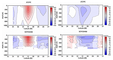
(JCOPE 2004/08/31-2004/09/01)
(ADCP 2004/08/31-2004/09/04)
Details in FIO
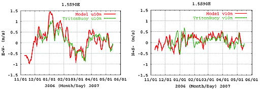
The FIO is developed based on open source Princeton Ocean Model (POM). The model horizontal resolution is about 10 km for the whole tropical Indian Ocean down to 30S and it has 48 layers in the vertical. Like JCOPE, FIO adopts 3DVAR data assimilation to assimilate all available observational data in the Indian Ocean. The following figures (velocity comparison of FIO and observation) show FIO's accuracy in predicting the highly fluctuating currents in the tropical Indian Ocean.
Details in FGO
The FGO is developed based on open source Princeton Ocean Model (POM). The model horizontal resolution is about 10 km for the semi-global from 60S to 60N and it has 44 layers down to 6500m depth. Like JCOPE, FGO adopts 3DVAR data assimilation to assimilate all available observational data in the global ocean. This world wide scale forecast with the high-resolution mode of FGO is the world's first commercial product in these fields.
Details in JCOPE-t
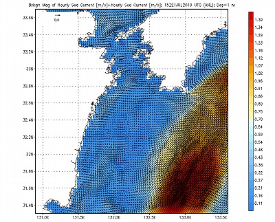
The JCOPE-t is an ultra-high-resolution model coupled with tidal model, covering the major part of the japanese coastal ocean with the resolution 3km in the horizontal and 46 layers in the vertical. It can reproduce the accurate current off the coast as it reflects run-off of the fresh water from major rivers and uses the daily updated wind data to improve wind-derived current. Houly forecast data for 4 days (current, tenperature, salinity, surface height) can be provided everyday.